


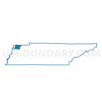
3-4 RIVES Voting District, Obion County, Tennessee
About
Outline

Summary
| Unique Area Identifier | 669313 |
| Name | 3-4 RIVES Voting District |
| County | Obion County |
| State | Tennessee |
| Area (square miles) | 93.48 |
| Land Area (square miles) | 92.61 |
| Water Area (square miles) | 0.87 |
| % of Land Area | 99.07 |
| % of Water Area | 0.93 |
| Latitude of the Internal Point | 36.33247200 |
| Longtitude of the Internal Point | -89.03999550 |
Maps


Graphs
Select a template below for downloading or customizing gragh for 3-4 RIVES Voting District, Obion County, Tennessee


Neighbors
Neighoring Voting District (by Name) Neighboring Voting District on the Map
- 04 Sharon Fire Station Voting District, Weakley County, TN
- 07 Vincent Implements Voting District, Weakley County, TN
- 1-1 SOUTH FULTON Voting District, Obion County, TN
- 3-2 KENTON Voting District, Obion County, TN
- 4-1 FAIR GROUNDS Voting District, Obion County, TN
- 6-1 TROY SENIOR CENTER Voting District, Obion County, TN
- 7-2 OBION CO. LIBRARY Voting District, Obion County, TN
Top 10 Neighboring County Subdivision (by Population) Neighboring County Subdivision on the Map
- District 4, Obion County, TN (4,891)
- District 6, Obion County, TN (4,507)
- District 1, Obion County, TN (4,459)
- District 7, Obion County, TN (4,253)
- District 3, Obion County, TN (4,245)
- District 7, Weakley County, TN (3,976)
- District 4, Weakley County, TN (3,545)
Top 10 Neighboring Place (by Population) Neighboring Place on the Map
Top 10 Neighboring Unified School District (by Population) Neighboring Unified School District on the Map
- Weakley County School District, TN (35,021)
- Obion County School District, TN (20,975)
- Union City School District, TN (10,832)
Top 10 Neighboring State Legislative District Lower Chamber (by Population) Neighboring State Legislative District Lower Chamber on the Map
Top 10 Neighboring State Legislative District Upper Chamber (by Population) Neighboring State Legislative District Upper Chamber on the Map
Top 10 Neighboring 111th Congressional District (by Population) Neighboring 111th Congressional District on the Map
Top 10 Neighboring Census Tract (by Population) Neighboring Census Tract on the Map
- Census Tract 9657, Obion County, TN (4,737)
- Census Tract 9682.01, Weakley County, TN (4,504)
- Census Tract 9654, Obion County, TN (4,429)
- Census Tract 9650, Obion County, TN (4,333)
- Census Tract 9656, Obion County, TN (4,081)
- Census Tract 9655, Obion County, TN (2,670)
- Census Tract 9651, Obion County, TN (2,505)
- Census Tract 9683, Weakley County, TN (2,322)
- Census Tract 9652, Obion County, TN (2,165)
- Census Tract 9658, Obion County, TN (1,796)
Top 10 Neighboring 5-Digit ZIP Code Tabulation Area (by Population) Neighboring 5-Digit ZIP Code Tabulation Area on the Map
- 38261, TN (16,919)
- 38237, TN (16,627)
- 38257, TN (4,397)
- 38260, TN (3,804)
- 38233, TN (2,852)
- 38255, TN (2,299)
- 38253, TN (1,156)